Chinese Journal of Vector Biology and Control ›› 2022, Vol. 33 ›› Issue (3): 371-378.DOI: 10.11853/j.issn.1003.8280.2022.03.011

• Vector Infectious Disease • Previous Articles     Next Articles

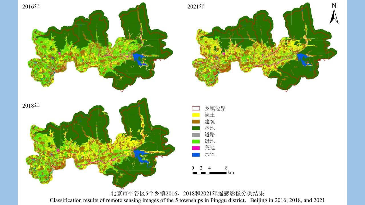
Correlation between scrub typhus incidence and land use in Pinggu district, Beijing, China

ZHAO Jia-xin1, LI Wen1,2, LI Gui-chang1, YUE Yu-juan1, LIU Qi-yong1, LU Liang1   

  1. 1. State Key Laboratory of Infectious Diseases Prevention and Control, Department of Vector Biology and Control, National Institute for Communicable Disease Control and Prevention, Chinese Center for Disease Control and Prevention, Beijing 102206, China;
    2. School of Public Health, Cheeloo College of Medicine, Shandong University, Ji'nan, Shandong 250012, China
  • Received:2022-03-01 Online:2022-06-20 Published:2022-06-11
  • Supported by:
    Science and Technology Basic Resources Investigation Special (No. 2017FY101202)

北京市平谷区恙虫病发病与土地利用的相关性研究

赵嘉欣1, 李文1,2, 李贵昌1, 岳玉娟1, 刘起勇1, 鲁亮1   

  1. 1. 中国疾病预防控制中心传染病预防控制所媒介生物控制室, 传染病预防控制国家重点实验室, 北京 102206;
    2. 山东大学齐鲁医学院公共卫生学院, 山东 济南 250012
  • 通讯作者: 鲁亮,E-mail:luliang@icdc.cn
  • 作者简介:赵嘉欣,女,在读硕士,从事鼠传疾病病原生物学研究,E-mail:zhaojiaxin0319@163.com
  • 基金资助:
    科技基础资源调查专项(2017FY101202)

Abstract: Objective To explore the relationship between the incidence of scrub typhus and land use in Pinggu district, Beijing, China. Methods The multi-scale segmentation and random forest algorithm in eCognition v9.0.1 software were performed to extract and classify the remote sensing image data of five townships (Wangxinzhuang town, Daxingzhuang town, Jinhaihu town, Nandulehe town, and Shandongzhuang town) in Pinggu district in 2016, 2018, and 2021 that had relatively large numbers of cases of scrub typhus. ArcGIS 10.7 software was used to calculate the area of each type of land in each township in each year. The relationship between the area of objects and the incidence of scrub typhus was analyzed through line graphs and Spearman's rank correlation analysis. Results The overall classification accuracy of remote sensing images of 5 towns in Pinggu district of Beijing in 3 years were all >80%, and the Kappa coefficients were between 0.600 and 0.800. The Spearman's rank correlation analysis showed that in the five townships, the incidence of scrub typhus was positively correlated with the ratio of green space area to non-forest land area from 2016 to 2018 (r=0.576, P=0.082), while there was no correlation between the incidence of scrub typhus and the proportion of object area from 2018 to 2021. From the perspectives of townships, in Nandulehe and Shandongzhuang towns, the incidence of scrub typhus was negatively correlated with bare soil/non-forest land ratio (all r=-1.000, all P<0.010), positively correlated with green space/non-forest land ratio (r=1.000, P<0.010), and negatively correlated with wasteland/non-forest land ratio (r=-1.000, P<0.010). However, there was a positive correlation between the incidence of scrub typhus and wasteland/non-forest land ratio in Jinhaihu town (r=1.000, P<0.010). The incidence of scrub typhus in the five townships was negatively correlated with building/non-forest land ratio in 2016 (r=-0.900, P=0.037), negatively correlated with water/non-forest land ratio in 2018 (r=-0.900, P=0.037), and positively correlated with water/non-forest land ratio in 2021 (r=0.900, P=0.037). Conclusion The incidence of scrub typhus in Pinggu district of Beijing was positively correlated with green space/non-forest land area ratio in 2016 and in 2018, but with no correlation between the two factors in 2018 and in 2021. The correlation results varied in different towns and different years.

Key words: Scrub typhus, Remote sensing, Land use, Green space, Wasteland, Bare soil, Random forest algorithm

摘要: 目的 探究北京市平谷区恙虫病发病与土地利用的相关性。方法 应用eCognition V9.0.1软件的多尺度分割和随机森林算法分别对平谷区累计发病数较多的5个镇(王辛庄镇、大兴庄镇、金海湖镇、南独乐河镇和山东庄镇)2016、2018和2021年的遥感影像数据进行地物提取和分类,ArcGIS 10.7软件统计每年各个乡镇土地类别的面积,分别通过构建折线图和Spearman秩相关分析探索地物面积与恙虫病发病率的关联。结果 北京市平谷区5个镇3年遥感影像的总体分类精度均>80%,Kappa系数为0.600~0.800。Spearman秩相关分析显示,2016、2018年,平谷区5个镇恙虫病发病率与绿地面积占非林地面积的比值呈正相关(r=0.576,P=0.082),而2018、2021年发病率与地物面积占比无相关性。按镇来看,南独乐河镇和山东庄镇的恙虫病发病率与裸土/非林地呈负相关(均r=-1.000,均P<0.010),与绿地/非林地呈正相关(r=1.000,P<0.010),与荒地/非林地呈负相关(r=-1.000,P<0.010),但金海湖镇的发病率与荒地/非林地呈正相关(r=1.000,P<0.010)。按不同年份来看,2016年5个镇的恙虫病发病率与建筑/非林地呈负相关(r=-0.900,P=0.037),2018年发病率与水体/非林地呈负相关(r=-0.900,P=0.037),2021年发病率与水体/非林地呈正相关(r=0.900,P=0.037)。结论 2016、2018年北京市平谷区恙虫病发病率与绿地面积占非林地面积的比值呈正相关,而2018、2021年二者无相关性。不同镇和不同年份的相关性结果不同。

关键词: 恙虫病, 遥感, 土地利用, 绿地, 荒地, 裸土, 随机森林算法

CLC Number: